Trips Places Foods Stories Newsletters

Take your next trip with Atlas Obscura!

Our small-group adventures are inspired by our Atlas of the world's most fascinating places, the stories behind them, and the people who bring them to life.

Visit Adventures
Trips Highlight
Puglia Italy - Matera
Italy • 8 days, 7 nights
Southern Italy: Castles, Caves & Coastal Treasures in Puglia
from
Turkmenistan Gates of Hell Darvaza crater
Turkmenistan • 10 days, 9 nights
Turkmenistan & the Gates of Hell
from
View all trips
Loading...
Loading...
Loading...

No search results found for
“”

Make sure words are spelled correctly.

Try searching for a travel destination.

Places near me Random place

Popular Destinations

  • Paris
  • London
  • New York
  • Berlin
  • Rome
  • Los Angeles
Trips Places Foods Stories Newsletters
Sign In Join
Places near me Random place
All the United States Nevada Gerlach High Rock Canyon Wilderness
AO Edited

High Rock Canyon Wilderness

Many generations of travelers have passed through the steep, smooth walls of this canyon.

Gerlach, Nevada

Added By
Jeremy Dunn
Email
Been Here
Want to go
Added to list
CAPTION
Aerial view of High Rock Canyon.   Jeremy D / Atlas Obscura User
The Applegate-Lassen Trail at High Rock Canyon.   Jeremy D / Atlas Obscura User
The Entrance to High Rock Canyon.   Jeremy D / Atlas Obscura User
Aerial close-up of canyon wall.   Jeremy D / Atlas Obscura User
A hazy day–there was rain later!   slgwv / Atlas Obscura User
Looking back.   slgwv / Atlas Obscura User
  slgwv / Atlas Obscura User
Bluffs by the road.   slgwv / Atlas Obscura User
  slgwv / Atlas Obscura User
Fly Canyon - To avoid the rocky canyon, at this location wagons were lowered with rope.   Jeremy D / Atlas Obscura User
What a little rain will do!   slgwv / Atlas Obscura User
Been Here
Want to go
Added to list

About

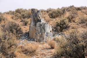
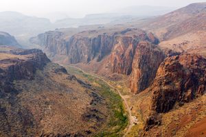
The rocks of this region are painted with layers of white, gray, orange and brown, which stand above lush green canyon floors muted sagebrush. This mountainous area was formed by ancient lava flows. About 17 million years ago volcanic activity moved across Nevada, spreading layers of dense lava as it moved southward. Tectonic activity turned these lava flows into mountain ranges, and millions of years of erosion smoothed steep canyon walls.

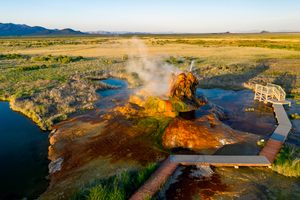
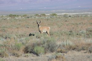
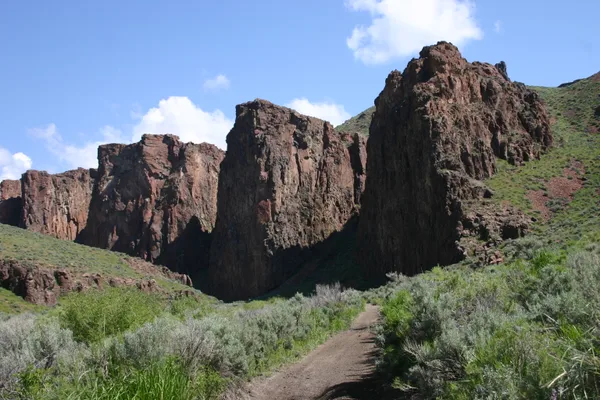
Several other gorges make up the area, such as Yellow Rock and Mahogany Creek Canyons. Mahogany Creek Canyon is so narrow at one point that visitors can touch both sides with arms outstretched. Due to a high water table, there are several springs in the area. It is common to see flowers in bloom during the late summer. Wildlife is abundant in the area.

High Rock Canyon and its surrounding lands have been inhabited for more than 10,000 years. Archaeologists have found evidence of stone tools, hunting traps, and fences made of juniper and sagebrush used by Indigenous people thousands of years before European colonists arrived. While several distinct tribes emerged in the Great Basin region, High Rock Canyon is commonly associated with the Northern Paiute people.

As European settlers pushed west, they encountered and often came into conflict with the Indigenous people of the Great Basin. Many of these explorers disregarded Indigenous communities while taking advantage of their deep knowledge of the land. Though the explorer John Fremont is often credited with the discovery of a path through High Rock Canyon in 1843, he was describing a trail established and used by Native Americans.

Several years later a group of settlers led by Jesse Applegate used a portion of Fremont’s route to establish an alternate trail to Oregon. High Rock Canyon became an important route in the westward migration to Oregon Territory and the California goldfields.

Crossing the nearby Black Rock Desert was a difficult and dangerous part of the journey. The flat, alkaline dry lake bed offered little water for travelers. Arriving at the canyonlands was a relief, as water and food were more abundant. However, navigating the canyons was not without its own difficulties. To enter the canyon, early settlers had to lower their wagons using a rope to the canyon floor.

Those early visitors were in awe when they laid eyes on the canyon. Vertical rock walls tower 300 feet over the trail below. Several settlers marked the occasion by carving their names into the rocks. Some wrote their names using axle grease, still visible today.

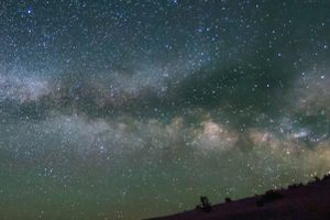
In 2000, Congress designated the land surrounding High Rock Canyon as a protected wilderness area in order to safeguard the cultural, historic, and natural significance of the area. Because the area is so remote, visitors can experience the night sky almost as brilliantly as its earliest inhabitants did. The lack of light pollution led to nearby Massacre Rim being named an International Dark Sky Sanctuary in 2019. The Summit Lake Paiute Tribe has a federal reservation located not far from High Rock Canyon Wilderness.

Related Tags

Canyons Nature Natural Wonders Natural History Native Americans Geology

Know Before You Go

This area is remote. There is no mobile phone service. A high-clearance four wheel drive vehicle is recommended. Plan on camping, as there are several designated sites. Bring plenty of food, water and a first-aid kit.

Although the area is frequently traveled, because there is water, the sagebrush and other plants grow abundantly. Expect to have your vehicle's paint scratched.

If you plan on accessing the area by crossing the Black Rock playa (dry lake bed), be aware that when wet, the surface turns to mud, and you will get stuck. The playa is best avoided from winter through early spring. Even a summer thunderstorm can temporarily halt travel. Soldier Meadows Road is a well maintained, gravel road that skirts the western edge of the playa.

The region can get heavy snow in the winter. High Rock Canyon Road is closed from late January until May 12th to protect wildlife habitats.

Community Contributors

Added By

Jeremy D

Edited By

raymondwinn1941, Vaquero, slgwv

  • raymondwinn1941
  • Vaquero
  • slgwv

Published

February 8, 2021

Edit this listing

Make an Edit
Add Photos
Sources
  • https://emigranttrailswest.org/virtual-tour/applegate-trail/
  • https://www.darksky.org/our-work/conservation/idsp/sanctuaries/massacre-rim-wilderness-study-area/
  • https://blackrockdesert.org/high-rock-canyon/
  • https://www.nevadawilderness.org/high_rock_canyon_wilderness
  • https://travelnevada.com/parks-recreational-areas/black-rock-desert/
  • https://www.nps.gov/grba/learn/historyculture/historic-tribes-of-the-great-basin.htm
  • https://www.thegreatbasininstitute.org/cultural-resource-assistance/
  • https://blackrockdesert.org/about-the-area/national-conservation-area/emigrant-history/
  • https://www.summitlaketribe.org/
High Rock Canyon Wilderness
High Rock Road
Gerlach, Nevada, 89412
United States
41.308503, -119.454921
Visit Website
Get Directions

Nearby Places

George W. Lund Petrified Forest

Gerlach, Nevada

miles away

Fly Geyser

Gerlach, Nevada

miles away

Massacre Rim Wilderness Study Area

Washoe County, Nevada

miles away

Explore the Destination Guide

Photo of Gerlach

Gerlach

Nevada

Places 6

Nearby Places

George W. Lund Petrified Forest

Gerlach, Nevada

miles away

Fly Geyser

Gerlach, Nevada

miles away

Massacre Rim Wilderness Study Area

Washoe County, Nevada

miles away

Explore the Destination Guide

Photo of Gerlach

Gerlach

Nevada

Places 6

Related Stories and Lists

Playing With Light and Perspective With One of Our Top Photo Contributors

List

By Jonathan Carey

Related Places

  • Winona, Missouri

    Rocky Falls

    A 40-foot waterfall flows into this unique natural swimming hole.

  • Al Wathba Fossil Dune Formations

    Abu Dhabi, United Arab Emirates

    Al Wathba Fossil Dunes

    These otherworldly formations were shaped over millions of years by the forces of nature.

  • Wheeler Geologic Area

    Creede, Colorado

    Wheeler Geologic Area

    This once-popular otherworldly landscape was formed by one of the largest volcanic eruptions in history.

  • View to the east.

    Ransom, Kansas

    Cedar Bluff Reservoir

    This 100-foot tall bluff located in the western plains of Kansas overlooks a massive reservoir.

  • Prästens Badkar (The Priests Bathtub)

    Simrishamn, Sweden

    Prästens Badkar (The Priests Bathtub)

    The world's only above water sand volcano, believed to once be the bathtub of a priest.

  • The sign for the iridium layer, located next to the exposed rock.

    Raton, New Mexico

    Raton Iridium Layer

    This unassuming layer of clay boasts an out-of-this-world origin story.

  • Mobius Arch

    Lone Pine, California

    Mobius Arch

    This rock formation named for its unique shape is one of many that call the Alabama Hills home.

  • Las Cruces, New Mexico

    Prehistoric Trackways National Monument

    Wee (and not so wee) footprints that insects and reptiles of the Paleozoic Era left behind.

Aerial image of Vietnam, displaying the picturesque rice terraces, characterized by their layered, verdant fields.
Atlas Obscura Membership

Become an Atlas Obscura Member


Join our community of curious explorers.

Become a Member

Get Our Email Newsletter

Follow Us

Facebook YouTube TikTok Instagram Pinterest RSS Feed

Get the app

Download the App
Download on the Apple App Store Get it on Google Play
  • All Places
  • Latest Places
  • Most Popular
  • Places to Eat
  • Random
  • Nearby
  • Add a Place
  • Stories
  • Food & Drink
  • Itineraries
  • Lists
  • Video
  • Podcast
  • Newsletters
  • All Trips
  • Family Trip
  • Food & Drink
  • History & Culture
  • Wildlife & Nature
  • FAQ
  • Membership
  • Feedback & Ideas
  • Community Guidelines
  • Product Blog
  • Unique Gifts
  • Work With Us
  • About
  • FAQ
  • Advertise With Us
  • Advertising Guidelines
  • Privacy Policy
  • Cookie Policy
  • Terms of Use
Atlas Obscura

© 2025 Atlas Obscura. All Rights Reserved.