Trips Places Foods Stories Newsletters
Loading...
Loading...
Loading...
Loading...

No search results found for
“”

Make sure words are spelled correctly.

Try searching for a travel destination.

Places near me Random place

Popular Destinations

  • Paris
  • London
  • New York
  • Berlin
  • Rome
  • Los Angeles
Trips Places Foods Stories Newsletters
Sign In Join
Places near me Random place
All the United States Washington, D.C. Waldseemüller’s 1507 World Map
AO Edited

Waldseemüller’s 1507 World Map

This groundbreaking 16th-century map is known as "America's birth certificate."

Washington, D.C.

Added By
dczippy
Email
Been Here
Want to go
Added to list
CAPTION
Waldseemüller’s 1507 World Map   Library of Congress
  Andreas Praefcke
  Andreas Praefcke
  Ryan Somma
Library of Congress, Jefferson Building   m01229
Library of Congress, Jefferson Building   Carol M. Highsmith / Library of Congress
Map using the word America from Introduction to the Cosmography   Adventures of a Carryon / Atlas Obscura User
  411shirley / Atlas Obscura User
Been Here
Want to go
Added to list

About

The Library of Congress' Thomas Jefferson Building houses the largest collection of maps in the world. Their Geography & Map Division manages over 5.5 million maps, 80,000 atlases (including a significant collection of Ptolemy atlases), 500 globes, reference materials, raised relief models, and a huge digital library. Their collections cover the world, with a special focus on the United States. The collection can be partially viewed online and by visiting the Geography & Map Reading Room or the exhibits in the Thomas Jefferson Building.

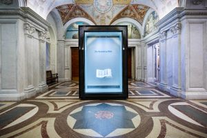
One of the most notable items is the only surviving copy of Martin Waldseemüller's world map from 1507. It is the first map to depict the Western Hemisphere as a distinct continent, surrounded by water and not connected to Asia. It also marks the first time "America" was used on a map to name the land mass, earning it the nickname "America's Birth Certificate."

Several Caribbean Islands appear in detail, along with a recognizable, if too thin, depiction of South America. A small piece of North America is visible. The Pacific Ocean is depicted for the first time—before Balboa or Magellan charted its waters. It also shows the rest of the "known" (by Europeans) world with varying degrees of accuracy.

Waldseemüller knew his map would be shocking and controversial at a time when the existence of entire "new" continents was still not accepted. He begged viewers, "This one request we have to make, that those who are inexperienced and unacquainted with cosmography shall not condemn all this before they have learned that it will surely be clearer to them later on, when they have come to understand it.”

The map is made of 12 separate sheets—when connected it measures 4.5 by 8 feet (1.4 by 2.4 meters). It is part of the permanent collection of the Library of Congress. The entire Library of Congress is worth visiting but the map is one-of-a-kind.

Related Tags

Cartography Libraries Repositories Of Knowledge Maps

Know Before You Go

You must reserve a free timed-entry pass from the Library of Congress website. Passes are released 30 days ahead. A limited number of same-day passes is released at 9am each morning. The pass is free and allows access to all public exhibits and spaces. The Library is closed Sunday and Monday.  

The closest Metro stop is Capitol South (Orange/Blue/Silver Lines) - Exit station using the main exit, walk approximately two blocks north on First Street SE. 

Community Contributors

Added By

dczippy

Edited By

411shirley, Michelle Cassidy, Adventures of a Carryon

  • 411shirley
  • Michelle Cassidy
  • Adventures of a Carryon

Published

November 16, 2022

Edit this listing

Make an Edit
Add Photos
Sources
  • https://blogs.loc.gov/loc/2021/06/the-birth-certificate-for-america/
Waldseemüller’s 1507 World Map
101 Independence Ave SE
Washington, District of Columbia, 20543
United States
38.888658, -77.004719
Visit Website
Get Directions

Nearby Places

Library of Congress Book Conveyor Tunnel

Washington, D.C.

miles away

Library Of Congress Gutenberg Bible

Washington, D.C.

miles away

Capitol Bollards

Washington, D.C.

miles away

Explore the Destination Guide

Photo of Washington, D.C.

Washington, D.C.

United States

Places 285
Stories 49

Related Places

  • Lewis Ansbacher Map Collection

    Jacksonville, Florida

    Lewis Ansbacher Map Collection

    This collection features more than 240 antiquarian maps from around the world, in addition to historical views and plates focusing on North Florida.

  • Leadhills Miners Library

    Leadhills, Scotland

    Leadhills Miners Library

    The oldest subscription library in Britain was started by lead miners in southwest Scotland.

  • Suzhou, China

    Map of Pingjiang

    You can still find your way around Suzhou with this 800-year-old stone map.

  • Wall of maps

    Ottawa, Ontario

    World of Maps

    A rare venue to buy specialty maps.

  • South and North America

    London, England

    'The World Turned Upside Down'

    Soon after its unveiling, this giant inverted globe sparked controversy and was vandalized.

  • Jane Austen’s name is emblazoned at the top of the telephone box.

    Steventon, England

    Jane Austen's Telephone Box

    The world's smallest Austen museum is inside an unassuming phone booth.

  • Pune, India

    Zero Stone of Pune

    One in a series of historical markers from the massive 19th-century undertaking to map all of India.

  • Herndon Fortnightly Club

    Herndon, Virginia

    Herndon Fortnightly Club

    In 1889, a small group of women began meeting to discuss literature, art, and other topics. Their every-other-week salon grew into a lending library that still exists today.

Aerial image of Vietnam, displaying the picturesque rice terraces, characterized by their layered, verdant fields.
Atlas Obscura Membership

Become an Atlas Obscura Member


Join our community of curious explorers.

Become a Member

Get Our Email Newsletter

Follow Us

Facebook YouTube TikTok Instagram Pinterest RSS Feed

Get the app

Download the App
Download on the Apple App Store Get it on Google Play
  • All Places
  • Latest Places
  • Most Popular
  • Places to Eat
  • Random
  • Nearby
  • Add a Place
  • Stories
  • Food & Drink
  • Itineraries
  • Lists
  • Video
  • Podcast
  • Newsletters
  • All Trips
  • Family Trip
  • Food & Drink
  • History & Culture
  • Wildlife & Nature
  • FAQ
  • Membership
  • Feedback & Ideas
  • Community Guidelines
  • Product Blog
  • Unique Gifts
  • Work With Us
  • About
  • FAQ
  • Advertise With Us
  • Advertising Guidelines
  • Privacy Policy
  • Cookie Policy
  • Terms of Use
Atlas Obscura

© 2025 Atlas Obscura. All Rights Reserved.