Trips Places Foods Stories Newsletters
Loading...
Loading...
Loading...
Loading...

No search results found for
“”

Make sure words are spelled correctly.

Try searching for a travel destination.

Places near me Random place

Popular Destinations

  • Paris
  • London
  • New York
  • Berlin
  • Rome
  • Los Angeles
Trips Places Foods Stories Newsletters
Sign In Join
Places near me Random place
All Vatican City Gallery of Maps - Galleria delle Carte Geografiche

Gallery of Maps - Galleria delle Carte Geografiche

Breathtaking and huge 430 year old maps of Italy.

Vatican City

Added By
Annetta Black
Email
Been Here
Want to go
Added to list
CAPTION
The gallery of maps, showing the ceiling   http://commons.wikimedia.org/wiki/File:Gol...
Map of Sicily   http://commons.wikimedia.org/wiki/File:Ign...
Orrery   http://commons.wikimedia.org/wiki/File:Pla...
Magnificent!   gabsterlamb / Atlas Obscura User
The Siege of Malta   hzoi / Atlas Obscura User
#nowords #surreal   mo1 / Atlas Obscura User
Musei Vaticani: Galleria delle Carte Geografiche   Jaszmina Szendrey / Atlas Obscura User
  briannafowler / Atlas Obscura User
Map of Sardinia   katielou106 / Atlas Obscura User
Been Here
Want to go
Added to list

About

Predating a unified Italy by nearly 300 years, the gallery of maps at the Vatican shows the length and breadth of the peninsula circa 1580.

Pope Gregory XIII commissioned the maps from his cosmographer, the multi-talented Italian priest Ignazio Danti. Danti had come to Rome from his post as mathematics professor in Bologna to help the pope with his efforts to correct the inaccurate Julian Calendar using modern Renaissance mathematics and astronomy.

At the time, cartography was undergoing its own renaissance. The age of exploration had brought new knowledge of distant lands, and technical innovations like the magnetic compass, sextant, and telescope improved accuracy. By the late 1500s the famous mapmakers Mercator and Ortelius were creating their landmark world maps. More significantly, before Danti took up his post in Bologna, he had spent a decade creating the magnificent hall of maps known as the Sala delle Carte Geografiche at the Palazzo Vecchio in Florence at the behest of Cosimo I de Medici, duke of Florence.

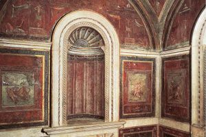
Maps were not new at the Vatican. Huge maps of the known world capped by a ceiling of stars were painted in the early 1500s in the Loggia della Cosmografia under the guidance of Pope Julius II (primarily remembered for commissioning Michelangelo to paint the Sistine Chapel).

To top that, Gregory set his sights on the 120 meter long corridor on the third floor of the Belvedere Courtyard. The ambitious project to install 40 enormous and highly accurate maps began in 1580 and took just 18 months to complete. Details of the large frescoes show the Siege of Malta, the Battle of Lepanto and large-scale maps of the maritime republics of Venice and Genoa. One map shows the Battle of Fornovo, the first battle in the Italian Wars against France. Each regional map is accompanied by a detailed view of its major city. The ceiling frescoes illustrate stories from the lands depicted below. Danti is also credited with the brass orrery that sits in the hall.

The gallery was restored and enhanced under Pope Urban VIII a century after it was created. Most visitors today pass through the gallery on their way to the Sistine Chapel as part of the Vatican Museums.

Related Tags

Marvelous Maps And Measures Repositories Of Knowledge Dead Explorers Vatican

Community Contributors

Added By

Annetta Black

Edited By

Rachel, hrnick, Jaszmina Szendrey, gabsterlamb...

  • Rachel
  • hrnick
  • Jaszmina Szendrey
  • gabsterlamb
  • hzoi
  • mo1
  • katielou106
  • briannafowler

Published

November 6, 2013

Edit this listing

Make an Edit
Add Photos
Sources
  • The marvel of maps: art, cartography and politics in Renaissance Italy, by Francesca Fiorani
  • http://en.wikipedia.org/wiki/Ignazio_Danti
  • https://tools.wmflabs.org/geohack/geohack.php?pagename=The_Gallery_of_Maps&params=41_54_15_N_012_27_17_E_type:landmark_region:VA_source:Wikidata
Gallery of Maps - Galleria delle Carte Geografiche
Vatican Museums, Viale Vaticano
00165
Vatican City
41.906498, 12.453425
Visit Website

Nearby Places

Stufetta del Bibbiena

Vatican City

miles away

'The Vision of Constantine'

Vatican City

miles away

Vatican Mosaic Studio

Vatican City

miles away

Explore the Destination Guide

Photo of Vatican City

Vatican City

Europe

Places 9
Stories 3

Nearby Places

Stufetta del Bibbiena

Vatican City

miles away

'The Vision of Constantine'

Vatican City

miles away

Vatican Mosaic Studio

Vatican City

miles away

Explore the Destination Guide

Photo of Vatican City

Vatican City

Europe

Places 9
Stories 3

Related Stories and Lists

13 Marvelous Maps That Go Way Beyond Paper

List

By Kavya Ram Mohan

Related Places

  • Florence, Italy

    Medici Hall of Maps (Sala delle Carte Geografiche)

    Over 50 exquisite hand-painted Renaissance maps decorate a Medici storage room.

  • The fireplace adorned by elephant tusks.

    New York, New York

    Explorers Club Headquarters

    A treasure trove of artifacts, books, and artwork from the "golden age" of exploration.

  • Detail of map

    Madrid, Spain

    Juan de la Cosa Map

    The earliest known map to show America, discovered by accident at a Paris bookshop.

  • Mercator Globe

    Sint-Niklaas, Belgium

    Mercator Museum

    Housing the groundbreaking maps and globes of Gerard Mercator.

  • Hargeysa Cultural Center’s Tape Wall

    Hargeisa, Somalia

    Hargeysa Cultural Center's Tape Wall

    An extensive audio-only collection of cultural heritage saved from a genocide.

  • Leadhills Miners Library

    Leadhills, Scotland

    Leadhills Miners Library

    The oldest subscription library in Britain was started by lead miners in southwest Scotland.

  • Markings on the old bridge

    Heidelberg, Germany

    Hochwassermarken

    Lines on the pillar of Heidelberg's Karl-Theodor Bridge record the dramatic heights of past floods.

  • Vienna Cloth Measures

    Vienna, Austria

    Vienna Cloth Measures

    These two 15th-century metal rods allowed people to check if they were swindled or not.

Aerial image of Vietnam, displaying the picturesque rice terraces, characterized by their layered, verdant fields.
Atlas Obscura Membership

Become an Atlas Obscura Member


Join our community of curious explorers.

Become a Member

Get Our Email Newsletter

Follow Us

Facebook YouTube TikTok Instagram Pinterest RSS Feed

Get the app

Download the App
Download on the Apple App Store Get it on Google Play
  • All Places
  • Latest Places
  • Most Popular
  • Places to Eat
  • Random
  • Nearby
  • Add a Place
  • Stories
  • Food & Drink
  • Itineraries
  • Lists
  • Video
  • Podcast
  • Newsletters
  • All Trips
  • Family Trip
  • Food & Drink
  • History & Culture
  • Wildlife & Nature
  • FAQ
  • Membership
  • Feedback & Ideas
  • Community Guidelines
  • Product Blog
  • Unique Gifts
  • Work With Us
  • About
  • FAQ
  • Advertise With Us
  • Advertising Guidelines
  • Privacy Policy
  • Cookie Policy
  • Terms of Use
Atlas Obscura

© 2025 Atlas Obscura. All Rights Reserved.